


visorando-st-laurent-d-oingt-ste-paule

hearly
User
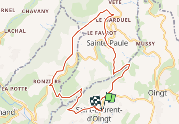

Length
10.3 km

Max alt
564 m

Uphill gradient
370 m
Km-Effort
15.3 km

Min alt
322 m

Downhill gradient
366 m
Boucle
Yes
Creation date :
2025-03-17 09:06:17.0
Updated on :
2025-03-17 09:06:19.88

FREE GPS app for hiking
 SityTrail
IGN / Geographical institutes
SityTrail Plus
The world is yours!
About
Trail of 10.3 km to be discovered at Auvergne-Rhône-Alpes, Rhône, Val d'Oingt. This trail is proposed by hearly.
Positioning
Country:
France
Region :
Auvergne-Rhône-Alpes
Department/Province :
Rhône
Municipality :
Val d'Oingt
Location:
Saint-Laurent-d'Oingt
Start:(Dec)
Start:(UTM)
621240 ; 5089126 (31T) N.
Comments